Topics covered: Creating geodatabases, ArcGIS Explorer, creating emergency maps related to the Joplin, Missouri Tornado.
Data Sources: UWF, Joplin and U.S.Census Bureau
Assignment: See Below.
Deliverables:
2 Maps
- A map of Joplin, Missouri showing county boundary and schools
- A map of buffered areas around the tornado path. The map should show the following:
- School locations
- Population estimate
- Impacted roads
Update Blog
- Post maps
- Process summary
- Create a Geodatabase.
- Display emergency information via ArcMap.
- Collect census, school, and boundary data from online sources.
The city of Joplin, Missouri suffered significant damage. For this assignment your task is to survey the areas of Joplin that were impacted by this disastrous tornado. You will examine the tornadoes path; locate schools and shelter that were affected by the tornado and determine the population density of the area impacted.
Part I: First Response Analysis
Step 1: Created a Base Map of Jasper County, Missouri
- Find data from online sources and bring into ArcMap:
- Jasper County Boundary
- Roads
- Schools
- Census Data (see steps taken in Tuscaloosa Lab write up)
- Census Tract (see steps taken in Tuscaloosa Lab write up)
3. Label Interstate and major roads.
4. Save the map document to my results directory
Deliverable 1: A map of Jasper County showing roads & schools
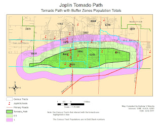
Step 2: Identify Tornado Path and Isolate Area of Concern - Create Buffers around the Tornado Path
- Used ArcMap to create a Multiple Ring Buffer (0.5 miles and 1 mile from the tornado path).
- Made sure the Buffer Unit was set to Miles. There was an interesting effect here. Initially my inner ring for the multipath ended up as .05 miles. I finally figured out (since it was repeatable) that if I chose .5 mile then selected miles from the meter default, the sw sometimes converted the .5 meters to .05 miles. I caught the error when I used the ruler tool to check my distances
- Displayed the buffer by “unique value” with distance as the value field.
- Experimented with various map display techniques until the I found the one that best expressed what was trying to be told.
- Saved the map document.
The schools are isolated:
- Within the tornado path
- 1/2 mile from of the tornado path.
- 1 mile from the accident scene
A. Download data from the U.S.Census Bureau
- 1. Download the Census Tract for Jasper County, Mo
- 2. Download the Census Data Table
The undergraduate lab was used for directions on how to “clean up” the data table. The key learning here was that there must be at least 2 columns of data that contain the identical names and unique values in both tables.
B. Join Census Table to CensusTract layer.
1. Once the data was “cleaned up” I used “Join” option on the Census Data Table to the Census Tract layer for Jasper County. This actually took several attempts until the join finally populated the fields with something other than
C. Determine Population and Roads Affected
Deliverable 2: A Map of the Buffered areas around the tornado path


No comments:
Post a Comment