Objectives:
This week we will focus on incorporating historic records, documents and images into GIS map documents for archaeological interpretation. Sources of historic information are numerous, and in many cases are essential tools for ‘reconstructing’ and interpreting the historic landscape. Images, maps, and documents can serve as sources for quantitative data, may be digitized for incorporation into a map document, or may be linked directly to a document for easy visualization and reference. The possibilities for utilizing historic documents in a GIS format are endless, and the importance of knowing where to find these sources of information, how to interpret them, and how to incorporate them into a GIS framework is a useful skill in the archaeologist’s toolset. This week we will:
- Locate, evaluate and interpret sources of historic information online
- Link historic images and documents into a map document for visualization and report production
- Link HTML site to a map document for enhanced resources interpretation and additional resources
- Gain familiarity with ArcGIS Online and user-created shared interactive maps
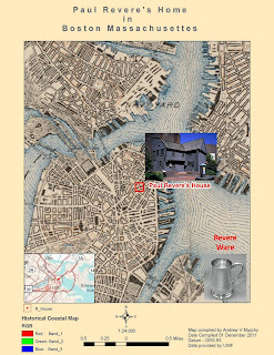
Create a final map in Layout view showing the following: historical map layer, Paul Revere house, Paul Revere portrait, original census record and html link to the Google Maps Street View image of the Paul Revere house (hint: insert a text box with the html). Make sure to include essential map elements such as a Title, scale, north arrow, legend, and source text. Do a little internet research and include a text box with a brief description of Paul Revere’s life and significance (three or four sentences). Try to imagine that you are creating a finished poster for a conference presentation: your map should be polished, present the data clearly, and should be aesthetically pleasing. Export the map to .jpg and submit to the Module 4 drop box.
Synopsis:
A good way to get a feel for the types, sources and availability of historic information is by examining an area with a plethora of historic documentation and a rich history. We will utilize historic census records and documentation to examine a famous site on the Boston Freedom Trail. You will learn how to locate, download, visualize and query census information and historical records, and will utilize that data to generate a final map document with linked historical documentation. Let’s get started!
Assignment 1: Locating Information
Base map Data
“The half of knowledge is to know where to find knowledge”: finding data to create a base map is perhaps the most essential and time consuming task that the GIS technician is faced with. For this exercise, most of the data has been collected for you, however it is imperative that you know how to locate and transform your own data.
Historical Records
The sources of historical data online can include museum websites, archives, libraries, universities, genealogy websites, and more. For the purposes of this lab, you will be required to register for the 14 day free trial of Ancestry.com (www.ancestry.com) although there are many sources for historical information; this website has many images, records and documents in one place and will serve as a good starting point for your research.
Assignment #2:
Generate Base map of Historic Boston
At times it may be difficult to find digitized historic data relating to your area of study. Internet searches may yield a plethora of modern shape files, but many historic data sources are not available to public domain due to security and preservation concerns. Fortunately, there are interactive web portals such as ArcGIS Online (www.arcgis.com) where other users of historical GIS may post the work that they have done for others to query. It is a good idea to be familiar with the site. For this lab, we will be utilizing one of the user-uploaded maps of the Boston Freedom Trail as part of our base map.

No comments:
Post a Comment